


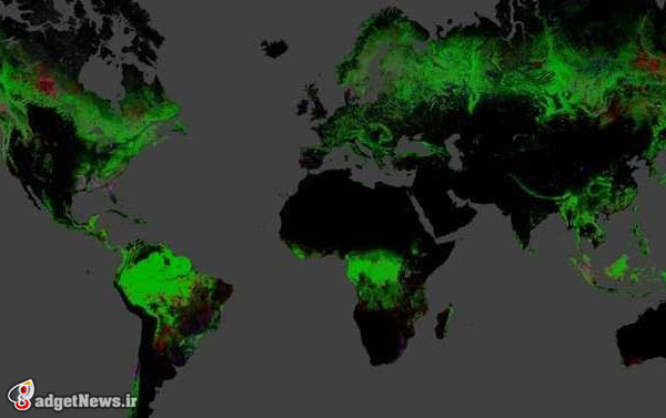
گوگل با همکاری محققانی از دانشگاه مریلند، ناسا و همچنین سازمان زمین شناسی آمریکا موفق شد به کمک موتور گوگل ارث، اولین نقشه با کیفیت وضعیت جنگل های جهان را در اختیار همگان قرار دهد.
در این پروژه از تصاویر سال های اخیر لَند سَت (Landsat) نهایت بهره برده شده. لَند سَت در حقیقت نام پروژه دیگری است که توسط سازمان زمین شناسی آمریکا اداره می شود و رسالت اصلی آن جمع آوری تصاویر ماهواره ای از سطح زمین است.
نقشه تهیه شده توسط گوگل تغییرات وضعیت جنگل های جهان را با جزئیات خیره کننده ای در قالب یک رابط کاربری ساده مشابه گوگل ارث، در اختیار عموم قرار می دهد. دولت ها و همچنین سازمان های غیر دولتی می توانند نهایت بهره از این نقشه را برده و سیاست های محیط زیستی خود را بر اساس این اطلاعات تعیین کنند.
برای تهیه این نقشه، ۶۵۴۱۷۸ تصویر لَند سَت مورد بررسی دقیق قرار گرفتند. قدرت پردازش مورد نیاز برای تحلیل این تصاویر به حدی بود که گفته می شود یک کامپیوتر باید ۱۵ سال تلاش می کرد تا به نتایج کنونی برسد. شاید پیشرفت تکنولوژی کامپیوتر در چند سال اخیر بود که باعث شده چنین نقشه ای با این رزولوشن به ثمر برسد.
در این نقشه تمامی تغییرات در وضعیت جنگل های جهان، از جمله بریدن درخت ها، تبدیل شدن جنگل ها به مزارع، کاهش پوشش گیاهی ناشی از بلایای طبیعی یا آتش سوزی، به کمک رنگ های مختلف نشان داده شده. به طور مثال این نقشه کاهش محسوس میزان جنگل ها در کشورهایی چون اندونزی و پاراگوئه را به تصویر کشیده.
این میزان عظیم از داده ها، آن هم در یک جا و تحت یک فرمت کاربرپسند، برای طرفداران محیط زیست و سازمان های غیر دولتی فرصت بسیار خوبی است که بتوانند سیاست های دولت های شان را در این زمینه به نقد بکشند.
منبع : businessinsider
Google Launches High-Resolution Deforestation Map
Google has teamed up with with researchers from the University of Maryland, NASA and the USGS to bring the first high-resolution map of global deforestation to life using Google Earth Engine. The project was created using over a decade of Landsat images and puts global land use changes into a format that the public, NGOs and governments around the world can use to learn more about forestry practices and hopefully help deter unwanted deforestation.
“People will use this data in ways we can’t even imagine today,” said lead author Matthew Hansen, Professor of Geological Sciences at the University of Maryland. The team hopes that people using the tool will look around and discover all of the information contained in the maps, but also possibly discover some new information too.
The tool was built by analyzing 654,178 Landsat images and required so much CPU that it would have taken one computer 15 years to process. In fact, it's only due to recent gains in computing technology that such a high-resolution map (scalable down to 30 meters) could exist in the first place. It's groundbreaking not just because of the high resolution, but also because it's the first tool to show forest cover and loss on a global scale — you can see the effects of what's happening locally in a global context.
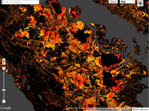
The tool allows you to jump to some specific examples of deforestation caused by things like logging and farm clearing, as well as natural disasters like tornadoes and wild fires. In the image below, forest loss is represented in red. The diagonal red line traces the path of the April 27, 2011 tornado that hit Tuscaloosa and Birmingham, Alabama.
Some other things documented in the tool are the progress made by Brazil in cracking down on illegal logging and deforestation over the past decade, but the map also shows the increasing forest loss in places like Indonesia, Paraguay and elsewhere. Studies show that tropical forest loss is increasing by 2,101 square kilometers (811 square miles) per year.
The creators of the tool hope that it can be used to help predict future land use changes and the effects of climate-related deforestation. With this amount of data being contained in such a user-friendly format, governments and other organizations can use the tool to make better policies to protect our forests.
You can check out the map and all of the layers here and read all about the study in the journal Science this week.


*در بین سایت های مشابه ، می تواند حائز رتبه خیلی خوب باشد . امید با از اهتمام و کوشش توفیق ارتقاء به کسب درجه ممتاز نایل آید .*