
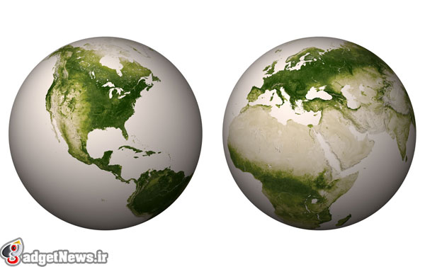
در نگاه اول به نظر تصویری ناقص از کره زمین می آید. اما این تصویر حرف های زیادی برای گفتن دارد چرا که این تصویر، پوشش فضای سبز کره زمین را نشان می دهد. ناسا در اینجا با ترکیب فناوری تصویر برداری مادون قرمز و نور مرئی شما را به مشاهد وضعیت گیاهان کره زمین می خواند. گیاهان نور مرئی را دریافت کرده و در مقابل نوری نزدیک به نور مادون قرمز را بازگشت می دهند که توسط دوربین های ماهواره ناسا ثبت شده است.
در این تصویر هر پیکسل نشانگر ۵۰۰ متر است و ماهواره VIIRS برای ساخت آن در هر دقیقه ۳۳۰ مگابایت اطلاعات را طی یک هفته جمع آوری کرده تا تصویر نهایی به دست آمده است.این ماهواره به طور دایم تصاویر جدیدی از این وضعیت تهیه می کند تا با مقایسه آنها با یکدیگر در طول زمان تغییرات پوشش گیاهی در کره زمین ثبت شود.
در حال حاضر به نظر می رسد که پوشش گیاهی به طور کلی در زمین در حال افزایش است اما به سوی شمال این کره حرکت می کند.
برداشت شما از این تصویر چیست؟
منبع : newscientist
Earth's plant life glows green in hi-res space map
This image of Earth stripped of clouds and oceans shows our planet's vegetation mapped at a higher resolution than ever before, thanks to the piercing eyes of NASA's Suomi NPP satellite.
The spacecraft's Visible and Infrared Imaging and Radiometer Suite (VIIRS) reveals plant life by measuring the amount of visible and near-infrared light reflected from the surface. Vegetation absorbs visible light to power photosynthesis, and leaf cells strongly reflect near-infrared light, so lush areas show much less visible light and more near-infrared than deserts and barren plains.
The astonishing detail of the map, which captures 500 metres per pixel, can be seen in this portion showing the rich Mississippi river delta. The VIIRS acquires 330 megabytes of data every minute for a week to build up this portrait of the planet's vegetation. Software then selects the clearest measurement for each spot on the planet, which is combined to create this vast 80,000-by-40,000-pixel cloud-free map.
By comparing weekly mosaics, researchers can track vegetation changes. These changes can herald outbreaks of drought and warn of the threat of wildfires – or even of malaria outbreaks. "As vegetation grows in sub-Saharan Africa, so does the risk for malaria," says the US National Oceanic and Atmospheric Administration, which generates the maps. "Vegetation indexes provide world health organisations the lead time needed to distribute supplies and medicine."
Overall, it looks like the planet is getting greener. Recent studies of similar satellite images have shown that plant life is moving north as carbon emissions stimulate photosynthesis.